Download Tutorial Lengkap (PDF 727 KB)
AERIAL PHOTOGRAPH & PLATFORMS
AERIAL PHOTOGRAPH
Aerial photography is the taking of photographs of the ground from an elevated position. The term usually refers to images in which the camera is not supported by a ground-based structure. Cameras may be hand held or mounted, and photographs may be taken by a photographer, triggered remotely or triggered automatically.
Platforms for aerial photography include fixed-wing aircraft, helicopters, multirotor Unmanned Aircraft Systems (UAS), balloons, blimps and dirigibles, rockets, kites, poles, parachutes, and vehicle mounted poles. Aerial photography should not be confused with Air-to-Air Photography, when aircraft serve both as a photo platform and subject.
1. Types of aerial photographs
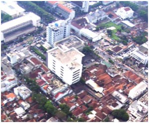
Oblique photographs
Photographs taken at an angle are called oblique photographs. If they are taken from a low angle earth surface–aircraft, they are called low oblique and photographs taken from a high angle are called high or steep oblique.
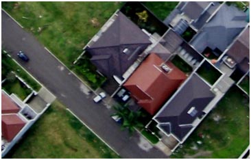
Vertical photographs
Vertical photographs are taken straight down. They are mainly used in photogrammetry and image interpretation. Pictures that will be used in photogrammetry are traditionally taken with special large format cameras with calibrated and documented geometric properties.
Combinations
Aerial photographs are often combined. Depending on their purpose it can be done in several ways, of which a few are listed below.
• Panoramas can be made by stitching several photographs taken with one hand held camera.
• In pictometry five rigidly mounted cameras provide one vertical and four low oblique pictures that can be used together.
• In some digital cameras for aerial photogrammetry images from several imaging elements, sometimes with separate lenses, are geometrically corrected and combined to one image in the camera.
Orthophotos
Vertical photographs are often used to create orthophotos, alternatively known as orthophotomaps, photographs which have been geometrically "corrected" so as to be usable as a map. In other words, an orthophoto is a simulation of a photograph taken from an infinite distance, looking straight down to nadir. Perspective must obviously be removed, but variations in terrain should also be corrected for. Multiple geometric transformations are applied to the image, depending on the perspective and terrain corrections required on a particular part of the image.
Orthophotos are commonly used in geographic information systems, such as are used by mapping agencies (e.g. Ordnance Survey) to create maps. Once the images have been aligned, or "registered", with known real-world coordinates, they can be widely deployed.
Large sets of orthophotos, typically derived from multiple sources and divided into "tiles" (each typically 256 x 256 pixels in size), are widely used in online map systems such as Google Maps. OpenStreetMap offers the use of similar orthophotos for deriving new map data. Google Earth overlays orthophotos or satellite imagery onto a digital elevation model to simulate 3D landscapes.
2 Aerial photography platforms
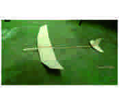
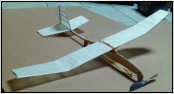
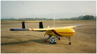
Radio-controlled aircraft
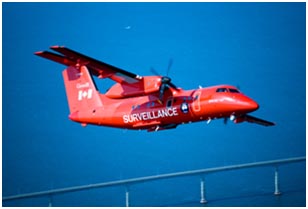
Advances in radio controlled models have made it possible for model aircraft to conduct low-altitude aerial photography. This has benefited real-estate advertising, where commercial and residential properties are the photographic subject. Full-size, manned aircraft are prohibited from low flights above populated locations. Small scale model aircraft offer increased photographic access to these previously restricted areas. Miniature vehicles do not replace full size aircraft, as full size aircraft are capable of longer flight times, higher altitudes, and greater equipment payloads.
Recent (2006) FAA regulations grounding all commercial RC model flights have been upgraded to require formal FAA certification before permission to fly at any altitude in USA.
In Australia Civil Aviation Safety Regulation 101 (CASR 101) allows for commercial use of radio control aircraft. Under these regulations radio controlled unmanned aircraft for commercial are referred to as Unmanned Aircraft Systems (UAS), where as radio controlled aircraft for recreational purposes are referred to as model aircraft. Under CASR 101, businesses/persons operating radio controlled aircraft commercially are required to hold an Operator Certificate, just like manned aircraft operators. Pilots of radio controlled aircraft operating commercially are also required to be licenced by the Civil Aviation Safety Authority (CASA).
Due to a number of illegal operators in Australia making false claims of being approved, CASA published and maintains of approved UAS operators.
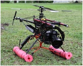
Multirotor Unmanned Aircraft Systems
A number of multirotor UAS are purposely built for aerial photography.
• Octocopters (8 rotors)
• Hexacopters (6 rotors)
• Quadcopters (4 rotors)
• Tricopters (3 rotors)
Multirotors have been the platform of choice for professional aerial photographers because they are mechanically simpler than helicopters, thus reducing the risk of mechanical failure. Correctly built and tuned they also offer less vibration and greater stability.
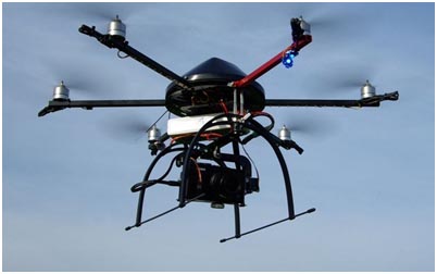
Multirotors generally have at least 2 rotors, however with the additional rotors, their payload lifting capacity and redundancy increases. If a 6 rotor aircraft loses power to one rotor it will lose yaw control. If an 8 rotor aircraft loses power to 1 rotor, there is negligible effect on control. This is an important design feature because unlike helicopters with a variable pitch rotor, multirotor aircraft do not have the ability to autorotate.
3 Basic Concept of Aerial photography
Focal length: the distance from the middle of the camera lens to the focal plane (i.e. the film). As focal length increases, image distortion decreases. The focal length is precisely measured when the camera is calibrated.
Scale: the ratio of the distance between two points on a photo to the actual distance between the same two points on the ground (i.e. 1 unit on the photo equals "x" units on the ground). If a 1 km stretch of highway covers 4 cm on an air photo, the scale is calculated as follows:
How to calculate scale on a photo. Calculate the scale taking the ratio of the distance between two points on a photo to the actual distance between the same two points on the ground.

Another method used to determine the scale of a photo is to find the ratio between the cameras focal length and the planes altitude above the ground being photographed.
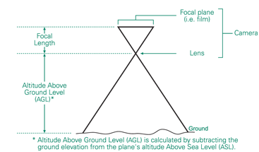
If a cameras focal length is 152 mm, and the planes altitude Above Ground Level (AGL) is 7 600 m, using the same equation as above, the scale would be:

Scale may be expressed three ways:
• Unit Equivalent
• Representative Fraction
• Ratio
A photographic scale of 1 millimetre on the photograph represents 25 metres on the ground would be expressed as follows:
• Unit Equivalent - 1 mm = 25 m
• Representative Fraction - 1/25 000
• Ratio - 1:25 000
Two terms that are normally mentioned when discussing scale are:
Large Scale - Larger-scale photos (e.g. 1/25 000) cover small areas in greater detail. A large scale photo simply means that ground features are at a larger, more detailed size. The area of ground coverage that is seen on the photo is less than at smaller scales.
Small Scale - Smaller-scale photos (e.g. 1/50 000) cover large areas in less detail. A small scale photo simply means that ground features are at a smaller, less detailed size. The area of ground coverage that is seen on the photo is greater than at larger scales.
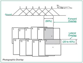
Overlap: is the amount by which one photograph includes the area covered by another photograph, and is expressed as a percentage. The photo survey is designed to acquire 60 per cent forward overlap (between photos along the same flight line) and 30 per cent lateral overlap (between photos on adjacent flight lines).
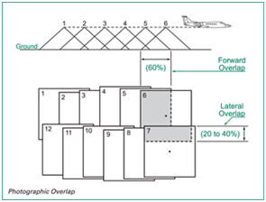
Stereoscopic Coverage: the three-dimensional view which results when two overlapping photos (called a stereo pair), are viewed using a stereoscope. Each photograph of the stereo pair provides a slightly different view of the same area, which the brain combines and interprets as a 3-D view.
Roll and Photo Numbers: each aerial photo is assigned a unique index number according to the photos roll and frame. For example, photo A23822-35 is the 35th annotated photo on roll A23822. This identifying number allows you to find the photo in NAPLs archive, along with metadata information such as the date it was taken, the planes altitude (above sea level), the focal length of the camera, and the weather conditions.
Flight Lines and Index Maps: at the end of a photo mission, the aerial survey contractor plots the location of the first, last, and every fifth photo centre, along with its roll and frame number, on a National Topographic System (NTS) map. Photo centres are represented by small circles, and straight lines are drawn connecting the circles to show photos on the same flight line.